Thursday 10 December 2009

London Map Samples

The People's Map of London was launched yesterday and following this announcement, here are a few sample images of what the raster product looks like. These will you a good idea of what to expect from the entire product.

Islington & Emirates Stadium


Westminster & Victoria Station


Southwark & Millwall Football Club


Tooting & St George's Hospital


If you are interested in either the complete raster maps or any of the vector products, please contact us at sales@peoplesmap.com

More info on the People's Map of London: http://peoplesmap.com/London.pdf

Wednesday 9 December 2009

People's Map launch London

We are proud to announce the launch of the brand new People's Map of London.

The People’s Map of London covers 400 sq km stretching from Richmond Park in the South West to Epping Forest in the North East. The rest of Greater London (inside the M25) is in final verification and will be available in early 2010.


Apart from London, we also have complete 1:12,000 scale street mapping of Birmingham, Glasgow, Edinburgh and Bath, as well as other cities in progress such as Bournemouth, Brighton, Cardiff, Portsmouth, Southampton, Coventry and Milton Keynes.

Over the next few years we aim to complete and maintain comprehensive mapping of the whole of Britain; we have already completed the whole country at a 1:1m (mini atlas scale) and we are well on the way to completing the 1:200,000 road atlas scale.

This first class mapping product comes with fair and flexible licensing too. Since the People’s Map is entirely free of third party copyright, we are able to offer you a flexible solution based on your exact requirements.

To download a PDF with more details on the People’s Map of London please click here.

Tuesday 10 November 2009

All Time Contributor Stats

Here is a list of the top 10 all time People's Map contributors. You will notice that JohnB, who won the Find Freddie competition, has moved into the top 10 for Point of Interest, Line String and Polygon creation with his efforts over the last few months.


In all three feature categories the People's Map is still in top spot since we originally imported the skeleton data, but are also constantly adding more data as part of our commercial projects.

Tuesday 3 November 2009

Freddie has been located!

The People’s Map Points of Interest competition, where users were asked to locate Freddie, an Australian tourist, has ended and we are pleased to announce that the winner of the competition is JohnB who not only located Freddie, but also won the prize for creating the most points of interest. JohnB created a total of 277 points of interests in London during the last three months. He only managed to locate Freddie’s position at the Imperial War M during final month just as other contributors were getting closer.


Congratulations to JohnB who wins £250 worth of High Street Shopping vouchers for finding Freddie, and another £250 worth for adding the most points of interest. We would also like to thank JohnB and all others who contributed POI's during this time.

Please keep contributing and keep your eyes peeled for the next competition!

For anyone who may not have been to the Imperial War Museum, here is a little bit of information about it.

In 1917 the Cabinet decided that a National War Museum should be set up to collect and display material relating to the Great War, which was then still being fought. The interest taken by the Dominion governments led to the museum being given the title of Imperial War Museum. It was formally established by Act of Parliament in 1920 and a governing Board of Trustees appointed. The Museum was opened in the Crystal Palace by King George V on 9 June 1920. From 1924 to 1935 it was housed, under very difficult conditions, in two galleries adjoining the former Imperial Institute, South Kensington. On 7 July 1936 the Duke of York, shortly to become King George VI, reopened the Museum in its present home.
More information can be found at http://london.iwm.org.uk/

Friday 2 October 2009

Find Freddie Competition Deadline Extended

Firstly we would like to say well done to all of you hunters out there who have been adding points of interest into the People's Map of London over the last two months and for trying to locate our lost tourist Freddie. You have contributed greatly to the map and it is very much appreciated.

However, no-one has yet managed to locate Freddie so we are going to extend the competition for a further month so that someone can win the £250 worth of high street shopping vouchers! To make it even easier, we are going to give you some clues over that month via Twitter, Facebook and this blog. These should help one of you to locate Freddie and win. If you are not already a follower or friend to People’s Map on Twitter or Facebook then find us using the following links:
http://twitter.com/peoplesmap
Facebook: Peoples Map

Someone has to win the £250 worth of shopping vouchers, so why not make sure it's you! The first clue will be released on Monday 5th October, so you have a few days to get prepared. You will have until 31st October 2009 to Find Freddie.

We have closed the other half of the competition for the person who contributed the most points of interest during August and September. The winner's name will be revealed shortly, once we have carried out the verification exercise. That person will have won £250 shopping vouchers. Just perfect with Christmas coming up!

So good luck to all in your pursuit of Freddie.

Tuesday 22 September 2009

People’s Map Adds Administration, Postcode and Health Authority Boundaries

The People’s Map has added new Administrative, Postcode and Health Authority boundary layers to its growing list of data products. Administrative layers include Unitary, County and Metropolitan Borough Councils. Postcode data includes areas, districts, sectors and centroids. Other boundary information includes Strategic Health Authorities and Primary Care Trusts, all supplied by People’s Map partner XYZ. These are all available for use in GIS and local information systems and in other digital file formats suitable for use in general office software and the web.

One of the first to benefit from this new data are Geowise who now offer a ‘Map Pack’ to compliment its InstantAtlas™ statistical visualisation platform. “Some of these layers are unique. The Map Pack we offer is the most cost-effective way of delivering ‘fit-for-use’ boundaries for InstantAtlas,” said Mike Forster Managing Director of Geowise.

Tuesday 15 September 2009

People's Map Update on RSPSoc 2009

The RSPSoc conference was once again a big success bringing in businesses and academics from all parts of the remote sensing and photogrammetry industry. Throughout the week there were many seminars and discussions linking to the current hot topic; freeing restricted datasets.

The People’s Map caused much debate in the presentation Chris Mewse gave on Thursday on how our map product is likely to change the landscape of digital mapping in the UK. As mentioned in the previous blog, the presentation aimed to encourage Universities and Online Learning Resources to adopt the People’s Map as an education and teaching tool. This concept has been met with much interest and we will start rolling out more trials of our WMS and GIS Data feeds very soon.

We’d like to thank the RSPSoc committee for holding such an interesting and diverse event, and also everyone who visited our stand and attended our presentation.

Monday 7 September 2009

People’s Map to present at RSPSoc in Leicester

This week, the UK’s largest Remote Sensing and Photogrammetry (RSPSoc) conference is being held in Leicester. This yearly event covers all aspects of the Earth Observation industry and aims to promote links between commercial, industrial, academic and international organisations to combine technologies and skills.

Remote sensing plays a key factor in the way the People’s Map works. We have been using high-resolution aerial photography, supplied by Getmapping, since we began and it allows our users to populate the map with accurate and up-to-date information. As an independent base layer of imagery it means our mapping stays free of Crown Copyright and empowers people to use the mapping in the way they want, without traditional restrictions.

As the People’s Map continues to improve its level of detail, we are beginning to assist higher education institutions by providing fit-for-purpose mapping through easily managed raster and vector feeds. Students can use the data for geomatics projects and develop their map skills through understanding and involvement of the map production process. The first trial will take place this academic year in the Remote Sensing and GIS department at Bath Spa University.

Chris Mewse (People’s Map & Getmapping) will be presenting this topic at the conference on Thursday in the learning seminar of RSPSoc. If you are unable to attend, please contact us if you would like more information.

Links:
RSPSoc - www.rspsoc2009.org
Getmapping - www.getmapping.com
Bath Spa University - http://www.bathspa.ac.uk/courses/undergraduate/gis.asp

Thursday 3 September 2009

People’s Map Underpins Edinburgh Festivals Guide

Visitors to this year’s Edinburgh Festivals including the Fringe were able to locate the numerous venues for the thousands of events with a new map based on the People’s Map of Edinburgh. The map produced by the Festival Fringe Society was available stand alone at A3 sponsored by Becks and also bound into the Official Guide to the Fringe sponsored by Magners.


People’s Map enables map makers to create their own styles and colour ways and then add data relevant to specific use, safe in the knowledge that the base map provides the vital geographic foundations. The large A3 map features colour coded locations for all the main Edinburgh Festivals’ venues including the International Festival, Art Festival, Fringe, Book Festival, Jazz & Blues Festival, Edinburgh Mela and the Military Tattoo. The map also contains information on Edinburgh’s wide variety of year round tourist attractions, bus and rail routes and much more. The smaller bound-in map provides information specific to the Edinburgh Fringe Festival.

This quality, detail and scale of mapping also exist for Birmingham, Glasgow and soon to be London. Apart from using this data for just map creation, this data is also available in GIS vector formats and also via the Openlayers API and People's Map WMS service.

Tuesday 11 August 2009

Monthly stats are back - July 2009

The data capture stats are back from this month onwards. Below are the top ten People's Map contributor's stats for the month of July.

You will notice that the stats for each geometry type of points, lines and polygons are displayed for the 1) last month as well as 2) a all time contributors list.


Friday 31 July 2009

The "Find Freddie" Competition

The People's Map has launched a competition today , called "Can You Find Freddie", where a total of £500 worth of high street gift vouchers can be won.

Freddie is an Australian tourist on holiday in London doing what tourists like to do best; visit the sights, check out bars and link up with friends who are over here to. There are many great sights to visit in London and in Freddie’s excitement to get out and see them all; he forgot to take a map with him. During his first day of sight seeing, he managed to get himself lost at one of London’s many tourist attractions and he now does not know where to go next. He needs your help!


In order for him to find his way and get his trip back on track, he needs you to help him create a tourist map of London by capturing as many genuine London points of interest as possible on the People’s Map.

The first person to add the point of interest where Freddie is lost will win £250 worth of High Street shopping vouchers! You add the points of interest via the editing suite in the People's Map. We have the location of Freddie written down in a secured golden envelope.

That’s not all. The person who adds the most genuine points of interest of London, to the People’s Map will also win a further £250 of High Street shopping vouchers!

The competition will run from the 1st of August 2009 to the 30th of September 2009, which therefore gives you two full months to “Find Freddie” and help him create a tourist map of London.

For more information, please visit the competition page: http://peoplesmap.com/Competitions.aspx


We look forward to announcing the winners in three months time!

Good luck and please let us know how you are getting on via the blog or forum.

Friday 3 July 2009

Transport Planning for Major Sporting Events

The People's Map and Getmapping exhibited at the "Transport Planning for Major Sporting Events" yesterday. The conference was held in Barbican, London where various industries specializing in the transportation and major events organisations were present.

Our stand, advertising our raster, vector and bespoke products, as well as Getmapping's vertical and oblique imagery solutions, drew many visitors from a variety of industries. Some of these industries were Planners, Event Security, Local Authorities, Transportation Information Solutions and Transport Map Makers.

In this day and age, maps and spatial products can be utilised in some or other way in almost every industry you can think off.

Thursday 25 June 2009

Product Samples

The People's Map is a work in progress and although we do not have map coverage at all scales for the entire UK, it is our mission to capture this. Here follows a list of images illustrating some of our products:

People's Map 1:10,000 Scale City Data


People's Map British Isles 1:200,000 Scale Data

People's Map British Isles 1:1million Scale Data


Apart from the above raster datasets, we also hold various other vector datasets like UK Admin Boundaries, UK Postcode Boundaries, Railways, Coastline, Rivers, Lakes, Mountains and all the vectors used to compile our raster products.

If you would like to obtain more detail regarding our products or request a sample, please contact us at sales@peoplesmap.com.

Tuesday 9 June 2009

They've made it to Barcelona!

Here is a letter from Paul and Chris who drove their £200 banger from Calais to Barcelona in aid of the MapAction charity:


"We made it!

Firstly, as we hope you are now all aware, we made it all the way to Barcelona in our £200 car without any major mishaps along the way.

Secondly, and more importantly, we made our fund-raising target thanks to the overwhelming generosity of YOU - our supporters. Thank you very much. In fact we have shattered our £3,000 target by a long way. When the gift aid element is added onto what has been donated so far, MapAction currently stand to receive almost £3,900 from this event.

Thanks are due also to our corporate sponsors, without whom we couldn’t have taken part in this event. Between them they have more than covered our costs and we have been able to divert an additional £1,000 into the charity. Not forgetting those who supplied the maps, the tracking facility and repaired and serviced our trusted car – The Green Goddess - now living a life of retirement in Barcelona (we hope)!

David Spackman, Chief Executive of MapAction, has asked us to pass on his own vote of thanks:

“MapAction is hugely honoured and impressed by the efforts of Chris and Paul to undertake the Barcelona rally on behalf of MapAction. The daily blog proved fascinating and we were glad of the opportunity to follow their GPS tracklog along the route. We were particularly pleased that they dropped into the MapAction office on their way. They did splendidly well and we’re proud of their sense of fun, practical hard work, and charitable aims.

We would also like to take this opportunity to thank everyone who supported the redoubtable duo and who made very generous donations to MapAction. It was a wonderful gesture by all those involved and MapAction is greatly appreciative for the kind donations. It has given us all a great fillip.

For the record during the car rally MapAction had volunteers in Papua New Guinea, Kathmandu, Panama, and in Norway/Sweden. We are about to despatch volunteer teams to Sri Lanka with the Mines Advisory Group, to Pakistan with the humanitarian logistics centre, and a separate team to the regional office of the UN in Islamabad. The money raised therefore by the car rally has helped MapAction to provide its present humanitarian GIS service. I hope all our donors will take satisfaction from this current record of charitable effort.

So special thanks to, and admiration for, Chris and Paul in the first instance, and a heartfelt thank you from MapAction to everyone who donated so generously.

David Spackman, Director MapAction”

So thanks again for all your support.

Best wishes

Paul and Chris"


The People's Map would like to congratulate Paul and Chris again on undertaking this challenge for a great cause!

Friday 29 May 2009

Data Verification Update

All data entered by our contributors are verified by a team of professional cartographers. We have recently upgraded the verification processes and due to the development of this functionality, no verification was performed during this time. We are now trawling through the back log and expect this process to take no more than 2 months.
This task is performed on a first in first out basis which means that the oldest roads are verified first until we have cleared the backlog. From this point onwards we expect items to be verified within 1 week as was always the case.

For those of you who are unsure of how the verification process works, here is a short explanation: When you create any new feature, it is recorded as an unverified feature and will only be displayed in the Unverified Map. This item is then downloaded and checked over by our team of verifiers which will look at the geometry, code and text of the feature created by the user. The geometry represents the placement of the feature, the code represents the type and the text represents the name such as road names and numbers. If all three items is correct, the feature is verified and will appear in the verified People’s Map layer. If the geometry fails verification, the feature is deleted. Please note that cartographic discretion is used when evaluating the geometry and only data that is totally out of place will be deleted. If the geometry pass, but the code or the text fails, only the text is deleted and the item remains unverified until updated.

Please refer to the following blog article explaining the different layers in People's Map. This article a clearly distinguish between the verified and unverified map.
http://peoplesmap.blogspot.com/2009/01/peoples-map-data-creation-process.html

We are currently developing a traffic light system that will highlight the unverified features with different colors according to the criteria for failing the verification process. Currently it not possible for our users to know if the features they created are still unverified because it has not been looked at or it has not yet passed the verification criteria.
If you have any questions regarding the verification process, please feel free to post your comments on this blog or alternatively contact us at info@peoplesmap.com.

Wednesday 20 May 2009

An Act Of CARtography

The People's Map donates maps for Barcelona Bangers Expedition


The XYZ Digital Map Company have provided Salford GIS with a range of People's Map, XYZ, and Global Mapping maps with which to decorate their vehicle for their Barcelona Bangers expedition.

The Barcelona Bangers event is a weekend long rally that sets off from Calais and terminates in Barcelona. Although not intrinsically an event for charity, many participant teams take the opportunity to raise money for a charity of their choice.

Paul Coward and Chris Nelson, from Salford GIS, have bought a “battered [16 year] old BMW”, costing £198, for the occasion and intend to raise at least £3000 for MapAction, a non-governmental organisation dedicated to providing field information and relief maps for disaster emergencies.


The two-man team will be departing from Southport on the 21st of May 2009 to join the other teams in Calais, before heading down to Barcelona on a trek, which lasts from Friday the 22nd, to Sunday the 24th of May... providing the car makes it. The one rule regarding the type of car that the 67 teams can use for their trip is that it should have cost under £200.

The participating teams are encouraged to decorate their vehicles, and in an inspired move, the People's Map in conjunction with The XYZ Digital Map Company, have agreed to provide maps for which to decorate the BMW.


We wish Paul and Chris the best of luck and hope their sub £200 banger makes it to Barcelona.


At least they will not get lost!

Friday 8 May 2009

Mapping the real world

“A car was left teetering on a cliff edge in Todmorden, West Yorkshire, after the driver followed satnav directions down a Pennine footpath”

This was a BBC news headline that appeared on 25th March 2009 and you can read the piece and watch a video at: http://tinyurl.com/d8ztyh

Contrary to what most people think even the best sources of mapping data can be wrong or misleading. What’s the point? I hear you ask. Well if you look at the aerial photograph of the path involved it is quite clear that this could never be considered to be a navigable road.


The People’s Map creation process using aerial imagery and in most cases local knowledge goes a long way to ensure high quality mapping. While this is not full proof it certainly demonstrates the value of our map making process!

Technical Problem: Missing Map Tiles

The People's Map servers experienced some technical difficulties during the morning, but all functionalities have been restored and the site is stable.

Please be aware that as testing and maintenance will continue through the weekend, the map and photography tiles could disappear for short periods of time.

Don't worry, this technical problem will not affect any of the data you have already or will be creating. The only affect is that there is a slight delay in the time your data appears in the unverified map layer.

We apologise in advance for any inconvenience this may cause.

Thursday 7 May 2009

New User and Editing Functionalities Deployed

New People's Map website functionalities were deployed to the website this morning. These functions include 1) New data editing functions, 2) New "Your Statistics" section and a 3) improved "Your profile" section.

1) Road Split: The new editing functionality that was deployed this morning allows users to split existing roads. This function will split a road at the point or node you select. This can for instance be used to split a road where a round about is required or where a road was digitised as one, but actually has more than one name.

We will publish a few tips and uses of the split functionalities in the People's Map forum under "Digitising Tips".

2) A new link to each registered user's personal data creation statistics was added to the website. When this option is selected, you will be able to view all your own data creation stats like how many items were created as well as total length (if appropriate). The stats are displayed under the categories Points, Linestrings and Polygons which again is shown for data created in the last 24hours, week, month, year and all time.

3) The Improved User Profile section now allows for registered users to change there registration email address, password and also there secret question. So when you change your email address or would like to change your password, you can do it all yourself.

We hope these improvements create a better user experience for all and please feel free to comment on these functionalities either via the Blog or via the Forum.

Monday 27 April 2009

The People's Map Forum

The new People's Map community forum was developed and made available to all People's Map users as part of the launch of the new site almost a month ago.

The purpose of the forum is to keep all users informed of developments, provide them with digitising guidelines & tips and more importantly encourage users to comment on the various aspect of the People's Map and its functionalities.

Here is a list of the existing forum topics:
1) Digitising Tips: Tips to assist contributors to create good quality and accurate data
2) FAQ's: Frequently Asked Questions
3) General: General People's Map related discussions
4) Technical: Technical related discussions, issues, resolutions, etc.

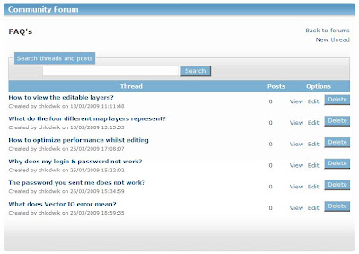
Each one of the above topics consists of various discussion threads where you as users can leave comments and make suggestions. Also note that each topic has a list of threads which is discussions related to that specific topic like to FAQ section illustrated in the image below.


In order for you to comment on any of the forum topics and threads, you should be logged on to the People's Map as a registered user. Please also note that you can either comment directly under the topic thread or you can comment on someone else's comments. To reply, just hit the reply link next to either the thread or one of the comments.

We hope you are finding this forum helpful and please feel free to suggest any other forum threads that you would like to see including in your community forum. We look forward to all your comments.

Wednesday 1 April 2009

Top Contributors for March 09

Here are the results of the Top People's Map Contributor as it stood on the last day before the new People's Map site was launched.

Many congratulations to Laurence Newman who is the top roads contributor of all time and to Matus who was the top roads contributor in March. I think Mapman also needs a mention is this post since he was on top of the standings for many months and have contributed a great deal to the People's Map data layers to date. He is still top of the all time log for creating Nodes.


Now that we have launched the new site, we look forward to a few new challengers to the top spot in the contributions standings!

Friday 27 March 2009

Helensburgh complete in just a couple of days

One of the People's Map contributors has already mapped the entire town of Helensburgh, Scotland since the launch of the new site this week. Here are a few images illustrating what progress can be made in just a day or two:

This aerial photo shows the extent of Helensburgh.


This image shows the original data that existed in People's Map before our contributor started to map Helensburgh.


This image displays the data created by the contributor on top of the aerial imagery.


The last image shows the new data already rendered into the People's Map unverified map layer, ready for validation.

All in four easy steps! Why not map your own town and let us know about it?

Wednesday 25 March 2009

The New People's Map is Launched

Many of you who read this blog on a regular basis will know that we have been working on the new People’s Map website for several months. Well today is the day we launch the new site and we are thrilled with the results.

Starting off with the new features you will notice at once that the new map window is much larger, which means less panning and zooming. In Edit mode nodes do not appear unless they are selected, making the mapping interface much less cluttered and easy to use.


We have also improved the map search capabilities, which produce better more accurate results... give it a try and let us know what you think.

Website performance is considerably enhanced especially in terms of panning and zooming. Many data structure improvements were also implemented to improve editing performance, but we will let you be the judge of that.

We have enhanced the discussion forums facility and we’ll be adding topics as they arise. We hope this will encourage better more focused feedback to the benefit of all.

More help is at hand too in the form of data capture guides and screen casts to provide all users & editors with better guidance on the various functionalities. We will be adding to these over time, therefore any feedback or input will be gratefully received.


That’s it! On behalf of everybody in the People’s Map team...Enjoy!

Monday 16 March 2009

Map Layers in peoplesmap.com

Most of you have probably noticed that there are four different raster map layers in http://www.peoplesmap.com/, but what do these maps represent and how can you use them?

1) The Getmapping Imagery layer contains the aerial photographs used as the base to create our mapping data from.


2) The People's Map layer contains all the verified map data and information created by our various private or commercial contributors. This map only contains data that was verified by our team of professional cartographers and will therefore be visible in the People's Map WMS layer used in GIS applications or our Open Layers API embedded into customer's web sites.


3) The People's Map Unverified Layer contains both map data verified as part of the process briefly described above and all other data created, whether verified or not. All unverified data is highlighted in purple.


4) The Out of Copyright Map is a 1940's map of Great Britain that is used as a reference to create and verify new mapping. Since this map is out of copyright, our users are allowed to use this data freely for our purposes.

Monday 2 March 2009

Top Contributors for February 2009

Congratulations to Laurence Newman who has overtaken the long standing "Mapman" on top of the All Time Road Creation rankings.