The People's Map was last night used on BBC Crimewatch. Here are a few snapshots of the Crimewatch presenters with the People's Map 1:1million scale map in the back ground.
Friday 27 February 2009


Friday 20 February 2009
People's Map African Connections
One of the People's Map Partners, Geosense, has a data capture and processing division in Cape Town, South Africa. Four members of the SA Geosense team has recently been trained to collect data for the People's Map and are currently actively capturing all roads, to a scale of 1:100,000 mapping for the entire United Kingdom. They have started in the North and will systematically work their way down to the South West tip of England. They have already completed Scotland and have recently started with the North of England. We estimate that this capturing process will take no longer than 6 months and by Summer 2009, you should notice a significant improvement to all major roads throughout the Peoples Map.
Below are a picture of the XYZ Digital Maps trainers (On the flanks) and the Geosense data capture team in the middle.

Apart from the creating 1:100,000 scale data for the Peoples Map, this data capture team also create maps for ad hoc projects, like for instance the London Land Use project. They have captured all land use, like parks, sport fields, lakes, dams, etc for the entire London inside the M25. They have also assisted with the creation of the road network for the Bournemouth & surrounding areas. Images of this data can be viewed in previous posts on the People's Map Blog. Al this data was captured externally from the People's Map website and therefore you can not be viewed in the People's Map data layers yet. We are planning to import this data in due course.
They form a integral part of the Peoples Map data capture team and you will notice many further improvements made by them over the next few years. Between the South African team, the Scotland team and all other individual People's Map editors, we should hopefully map the entire UK at all scales in no time!
Monday 16 February 2009
Corby road map complete
We recently completed a mapping project for the town of Corby in Northamptonshire. The objective of this project was to map and name all the roads of Corby and the surrounding area.
All the roads were initially captured in the People's Map. A GIS survey team then travelled to Corby to field check the accuracy of the road data created in People’s Map. Since Corby has developed quite rapidly over the last few years, the survey team found that the aerial imagery (2006) was not up to date enough to capture all the roads so embarked on a GPS survey of these roads. As part of this field check and survey exercise, all the road positions and attributes where checked and verified.
The 1st image below shows the raw GIS data in blue that was captured in People’s Map from the 2006 Aerial Imagery as source and the GPS surveyed data in red, overlaid on a snapshot of the existing PM extent. This red GPS surveyed data is not yet visible in People’s Map as yet, but is sceduled to be imported into the online version in the near future.

The 2nd image shows a graphically modified road map of Corby. This data will now be used by our client to create a final map, including various layers like railways, parks, etc.
 The People’s Map is proud to say, due to the extent of this data capture project, we currently hold the most up to date map of Corby that exists.
Monday 9 February 2009
People's Map of Scotland
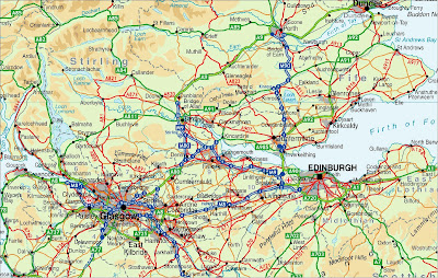
This is a A0 Map of Scotland that we recently produced for one of our clients. This map was created from the People's Map 1:1,000,000 scale mapping of the UK.
 Here is the same 1:1,000,000 data, but only zoomed in much closer. This image below shows the level of detail that is contained within the People's Map 1:1,000,000 mapping. Note that we have coverage to this scale for the entire UK.
 Here is a snap shot to illustrate the level of detail contained in the South of England:
 Here is the same 1:1,000,000 data, but only zoomed in much closer. This image below shows the level of detail that is contained within the People's Map 1:1,000,000 mapping. Note that we have coverage to this scale for the entire UK.Here is a snap shot to illustrate the level of detail contained in the South of England:
Friday 6 February 2009


Wednesday 4 February 2009
Bournemouth, Poole, Christchurch and surrounds complete
All the roads for Bournemouth, Poole, Christchurch and the surrounding areas has now been captured by the People's Map production team. The image below illustrates the extent of the data captured.
 This data is not yet visible in People's Map, as this data was not captured within People's Map, but off line in MapInfo Professional. This data is currently being checked and verified and will then be imported into the live People's Map system for all to view and edit.
Subscribe to:
Posts (Atom)

